Madagascar Surf Trip Vacation Destinations
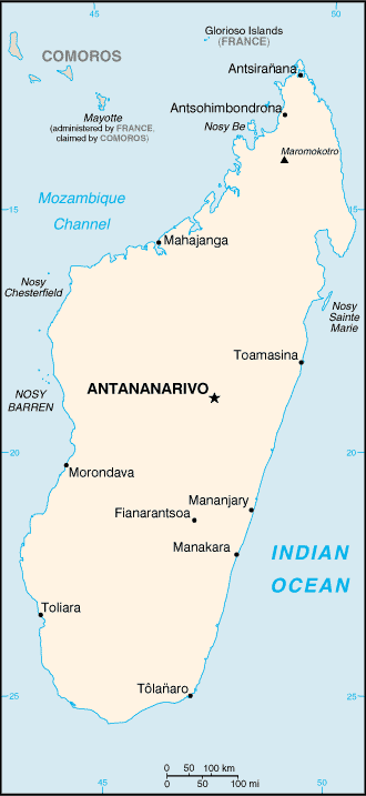
Geography: Madagascar can be divided into five geographical regions: the east coast, the Tsaratanana Massif, the central highlands, the west coast, and the southwest. The highest elevations parallel the east coast, whereas the land slopes more gradually to the west coast.
The west coast, composed of sedimentary formations deposited in several layers over time, is more indented than the east coast, especially in the northwest, thus offering a number of fine harbors sheltered from cyclones, such as the harbor at Mahajanga. Deep bays and well-protected harbors have attracted explorers, traders, and pirates from Europe, Africa, and the Middle East since ancient times; thus, the area has served as an important bridge between Madagascar and the outside world. Yet the broad alluvial plains found on the coast between Mahajanga and Toliara, which are believed to have great agricultural potential, are thinly inhabited and remain largely unexploited.
The southwest is bordered on the east by the Ivakoany Massif and on the north by the Isala Roiniforme Massif. It includes two regions along the south coast, the Mahafaly Plateau and the desert region occupied by the Antandroy people.
The Climate is dominated by the southeastern trade winds that originate in the Indian Ocean anticyclone, a center of high atmospheric pressure that seasonally changes its position over the ocean. Madagascar has two seasons: a hot, rainy season from November to April; and a cooler, dry season from May to October. There is, however, great variation in climate owing to elevation and position relative to dominant winds. The east coast has a subequatorial climate and, being most directly exposed to the trade winds, has the heaviest rainfall, averaging as much as 3.5 meters annually. This region is notorious not only for a hot, humid climate in which tropical fevers are endemic but also for the destructive cyclones that occur during the rainy season, coming in principally from the direction of the Mascarene Islands. Because rain clouds discharge much of their moisture east of the highest elevations on the island, the central highlands are appreciably drier and, owing to the altitude, also cooler. Thunderstorms are common during the rainy season in the central highlands, and lightning is a serious hazard.
The southwest is Madagascar's surfing wonderland. Many high-quality breaks can be found among the area's coral reefs. Given the orientation of the coast, and the direction of the prevailing swells, the best of these breaks tend to be lefts, although rights are also present. More Madagascar Surf...
Madagascar Map:
Back to Indian Ocean Surf Trip Vacation Destinations Travel Directory... |