Mauritania Surf Trip Vacation Destinations
Geography:
Area: 1,030,070 sq. km. (419,212 sq. mi.); slightly larger than Texas and New Mexico combined.
Cities (2004): Capital--Nouakchott (pop. 708,000). Other cities--Nouadhibou (72,000), Rosso (50,000), Kaedi (34,000), Zouerate (34,000), Kiffa (33,000), Atar (24,000).
Terrain: Northern four-fifths barren desert; southern 20% mainly Sahelian with small-scale irrigated and rain-fed agriculture in the Senegal River basin.
Climate: Predominantly hot and dry.
The Coastal Zone, or Sub-Canarian Zone, extends the length of the approximately 754-kilometer-long Atlantic coast. Prevailing oceanic trade winds from the Canary Islands modify the influence of the harmattan, producing a humid but temperate climate. Rainfall here is minimal; in Nouadhibou it averages less than three centimeters annually and occurs between July and September. Temperatures are moderate, varying from mean maximums of 28°C and 32°C for Nouadhibou and Nouakchott, respectively, to mean minimums of 16°C and 19°C.
Battering surf and shifting sand banks characterize the entire length of the shoreline. The Ras Nouadhibou (formerly Cap Blanc) peninsula, which forms Dakhlet Nouadhibou (formerly Lévrier Bay) to the east, is fifty kilometers long and up to thirteen kilometers wide. The peninsula is administratively divided between Western Sahara and Mauritania, with the Mauritanian port and railhead of Nouadhibou located on the eastern shore. Dakhlet Nouadhibou, one of the largest natural harbors on the west coast of Africa, is fortythree kilometers long and thirty-two kilometers wide at its broadest point. Fifty kilometers southeast of Ras Nouadhibou is Arguin. In 1455 the first Portuguese installation south of Cape Bojador (in the present-day Western Sahara) was established at Arguin. Farther south is the coastline's only significant promontory, seven-meter-high Cape Timiris. From this cape to the marshy area around the mouth of the Senegal River, the coast is regular and marked only by an occasional high dune.
On coastal dunes vegetation is rare. At the foot of ridges, however, large tamarisk bushes, dwarf acacias, and swallowworts may be found. Some high grass, mixed with balsam, spurge, and spiny shrubs, grows in the central region. The north has little vegetation.
Mauritania Map: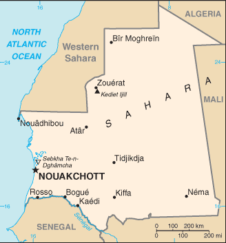
Back to Africa Surf Trip Vacation Destinations... |